
Turkey is almost all mountains. From the Aegean coast the land rises rapidly to about three thousand feet (1,000 m), and thence the bumpy, arid plateau stretches eastward for some five hundred miles till it merges into the eastern mountain ranges. High mountains guard the northern and southern coasts, stealing the rain before it reaches the plateau. The rain that does penetrate falls unevenly, sometimes in cloudbursts which destroy standing crops and wash away top soil. Capricious weather often undoes the farmer's work, and disappointing harvests are frequent. Summers are hot and dry, winters intensely cold, with snow sometimes lying up to three months. As one goes east, this tough climate grows tougher.
Kayseri lies in the centre of Turkey, in one of the large plains sunk in the plateau. It had been and still was in 1950 a central point in Turkey's transport system, since the main railway and roads[1] from Istanbul and Ankara to both east and south ran through or very close to it. Besides its commercial, agricultural and administrative importance, Kayseri had in 1949 the largest textile mill in Turkey, built in 1935 with Russian help under the first five-year plan. In 1950 it had a population of 65,000 (Ann. Stat. 1951).
Immediately south of the town, the land rises towards the solitary, volcanic peak of Erciyas, 12,860 feet high, but otherwise the country is typical plateau in all directions. The broad valley in which Kayseri lies runs north-east from the town, carrying the main road and railway to Sivas and the east. This
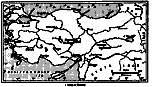 Figure 1
Sakaltutan is fourteen miles farther east, the last village of the Talas nahiye. Only two years before our arrival, a rough village road had been made just passable for motor traffic, joining Tomarza, the next nahiye centre out, in the kaza of Develi, to Kayseri. Passing through the village to the north of Talas1 this road climbed across steep valleys and sharp hills as far as Sakaltutan, which lay at the foot of the slopes rising towards Erciyas, at about 5,500 feet, some twenty miles from Kayseri. Thence the road swung south-east round the base of the mountains and slowly fell towards Tomarza.
Another fork of the road, also just passable for lorries, branched off at Sakaltutan and ran slightly north of east, down into a wide valley, through three or four villages until it reached Elbashï, the next nahiye centre, at about 4,000 feet, and only about four miles from an alternative main road from Kayseri, through Bunyan to Pïnarbashï. Elbashï was attached administratively to Bunyan, about fifteen miles away, and over forty miles by the main road from Kayseri. In village terms, Kayseri to Sakaltutan was six hours, Talas to Sakaltutan four or five hours, and Sakaltutan to Elbashï four or five hours. Although the lorries and the new roads had rendered this way of measuring distances obsolescent, it was still the normal way of talking about distances.
Sakaltutan was of medium size - about one hundred households and just over six hundred people. Elbashï was well above the village average for the area, with over two hundred house-
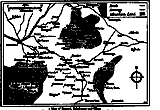 Figure 2
{18}
holds and about 1,200 people, and was exceptionally well endowed with land.
Sakaltutan has more severe winters and cooler, breezier summers. It has a natural spring greatly superior to the stagnant wells on which some surrounding villages rely, but this does no more than provide a small pond for the buffalo, and dampen a few fields immediately below the village meadow. Other small springs emerge at various points in the village territory, making green dells of fresh pasture, and patches of more productive ground. Elbashï is much less snowbound in winter, but unpleasantly hot in summer. It boasts a major spring of water, which not only supplies fountains in the village, but furnishes a considerable permanent stream, irrigating the wide fields of the floor of the valley in which the village stands. Beside this stream stretches a long strip of water meadow.
But most of the land of both villages is either dry arable land, given over. to extensive cultivation of cereals, mainly rye and wheat, or else uncultivable and rocky pasture. For Alïshar, (p. 134) Morrison found only fifty-five per cent of the land cultivable (Morrison (1938) Chap. II), and I would guess roughly the same to be true here. From any hill-top a vast undulating plateau can be seen stretching away to mountains. To the south and east are the distant ranges of the Taurus, snowclad most of the year. Much closer, to the south-west, stands Mount Erciyas. Here and there a small group of trees, or a vineyard climbing up a hillside indicate the site of a village. This undulating appearance is deceptive, for the plateau in this region is cut by sharp valleys and escarpments, where the hard layer of rock ends abruptly in a steep slope covered, often, with chunks of rock which have broken off and rolled down. These escarpments provide access to softer underlayers, wherein it is easy to hollow out a cave, or to excavate and use the hillside as one wall of a house. Like most of the villages, Sakaltutan lies against one of these escarpments, on the edge of a shallow valley. The vertical break in this case is only about twenty to thirty feet high, and is now hidden behind a front of old houses. The ground slopes away, dotted with newer houses, to the meadow in the bottom of the valley.
Round Elbashï which is not quite visible from Sakaltutan, the country is
flatter. The village sits on a small rocky bump, which
{19}
 Figure 3
{20}
gives an easily worked rock for cave-making. Willows and straight poplars, so common
in the villages of central Turkey, grow along the stream in considerable numbers
and give it the distant appearance of a green oasis in a treeless waste. The disorderly
array of flat-roofed and irregular houses in local stone give the villages a half
tumble-down appearance. This impression is not altogether false. Much new building
is in progress, and many older houses have been abandoned, and their valuable roof
timbers removed. On closer inspection, most of the houses are occupied and solidly
built. The streets are haphazard - people have built as and where they chose. In.both
villages, and especially in Elbashï, many of the new houses are well away from
the village centre, and some of them have their own wells, being too far from the
village fountains. The village mosques were in neither case remarkable. They looked
from the outside like larger versions of village houses, except that an outside staircase
ran up to roof level, ending in a platform covered by a small pinnacle which constituted
the minaret. Inside, the floor was covered with rugs, where the faithful came shoeless
to perform their ritual prayers or to listen to the Holy Koran.
Many villages now have one red-roofed school building, conspicuous with its new white walls. But Sakaltutan had not achieved this distinction; its school building was a stone, flat roofed building, two unused rooms of which became my home.
Elbashï, by contrast, had four public buildings; an old flat roofed stone school dating from the nineteen-twenties, a new red-roofed school, a house, not occupied, for a village health officer (Sihhat Memuru) and an older tin-roofed building which acted as headquarters for the nahiye, and housed four gendarmes and a sergeant.
The stone houses vary in size and layout, depending mainly on the size of the
household and its wealth. One or two families in Sakaltutan still lived in caves.
One cave had been newly made for a young couple. Caves, after all, are not only cheaper,
but better insulated against heat and cold, do not leak in heavy rain - most flat-roofed
houses do - and require no upkeep. The
{21}
earlier inhabitants of the village probably lived in caves or houses with their animals
at one end and themselves at the other, but only one or two households still had
this arrangement. Most houses have caves behind or below the house, where animals
are kept, and straw for winter feed is stored. These often have clear signs of previous
habitation.
Every village home has a main living-room, called in this area ev, the normal Turkish word for house. In this room is the fireplace, a beehive-shaped oven called tandir, let into the mud floor, supplied with draught by a bullt-in pipe. The opening at the top is at floor level, and normally covered with a large flat stone - a deadly trap for babies if this stone is inadvertently left off. The ovens provide for warmth and cooking, burning dried cakes of cattle dung mixed with straw, which will smoulder for hours. When the tandir is first lit in the morning the room is filled with dense acrid smoke and everyone crawls, or walks around bent double, until it has cleared through the hole provided in the roof.
The ev is the scene of all household activities. Here are shelves of earthenware vessels and tinned copper pots and pans. Great wooden chests store the family supply of grain and flour. An upright loom serves for the women to weave woollen rugs, saddle bags and grain sacks. Round the oven, when guests call or the women have time to sit, are spread mats and rugs and cushions. Rolls of bedding - mattresses, quilts and pillows stand in a neat pile, or sometimes in a special recess.
This room is the province of the wife of the household head, where she sleeps with her husband and at least her younger children. Her own chest, which came with her when she married, holds her own and usually her husband's personal possessions, safely under lock and key. No man enters the ev of a household other than his own unless he is very close kin-even a first cousin of one of the couple might hesitate - unless he has very special business, when he will knock and call out to give warning.
Almost all homes have more than this one room. Most are entered through a high-walled
courtyard, and off this or behind the ev are a stable, a cave or building that acts
as a barn, and possibly other storage rooms. A second tandir is normally placed somewhere
out of doors, but sheltered from direct rain. Junior married couples should and normally
do have their own room
{22}
where they sleep with their children, and keep their personal possessions.
The wealthier homes, and some of the less wealthy, have also a special room for the men of the household, where they sit in the evenings, brew coffee or tea if they can afford it, and entertain neighbours and guests. These rooms are much more luxuriously furnished. They invariably have a built-in sedir, a divan which runs right round the walls, or in the older design, run like tramlines facing each other along one side of the room. Originally these rooms were heated by open hearths, but in the last ten or fifteen years these had been ousted by small sheet-iron stoves. The divans are covered with rugs, carpets and cushions. The floors are usually of stone, or even wood, and the windows are large, by village standards. The few really large rooms of this type in each village are used for weddings and other large-scale entertainments, and are often approached by a small ante-room in which coffee is made on important occasions. The villagers call these `guest rooms' misafir odasi (sing.) or more simply just oda (room). These are in fact much more than guest rooms. But since they correspond roughly to similar rooms - or tents in other Middle East societies, which are usually called `guest rooms', it is perhaps best to use this term. In contrast to the main living room, (ev), the guest room (oda) belongs to the men and should preferably stand apart from the rest of the home, or have a separate entrance, so that male visitors see nothing of the home at all.
Sakaltutan is not an old village. On the meadow is a tomb or turbeh, said by the villagers to be that of a Muslim commander named Mehmet Miktat, killed in a battle with Byzantine forces. There is another small burial ground said to contain the bodies of martyrs who. died in this battle. Some marks on rocks in another part of the village were said by the present inhabitants to be tombs left by a previous Christian village on the site.
The present village was probably founded by people from villages nearer Kayseri,
who had first made a temporary summer camp there for pasture, and later decided to
settle permanently and plough. All the villagers could tell me was
{23}
that four brothers founded the village, though no one could give their names or genealogical
link with the present inhabitants. The longest genealogies were six generations above
elderly living men. Assuming that the first man named was, as they claimed, born
in the village, and that a generation averages about twenty-five years, this would
take us back over two hundred years without arriving at the original four brothers.
The local sergeant of gendarmes commented that Sakaltutan was not an old village,
and guessed two hundred years - which may not be far out.
Elbashï is undoubtedly much older. Again, no one knew much about village history. One village story of an imperial visit implied its existence in the reign of `Murad Padishah', presumably Murad IV, who reigned from 1623 to 1640. In recent times, it has been an administrative centre, and several recent ancestors of village households were said to have held the office of local müdür. It certainly has a good deal more land than most other villages in the area.
In both villages, the population has apparently expanded rapidly in the last generation and is still increasing. Sakaltutan, now just over one hundred households, is remembered by old men when it was only sixty households, and a middle-aged man in Elbashï spoke of a population of four hundred and fifty in his childhood, whereas it now has about twelve hundred. In Sakaltutan, this increase was natural. The three most recent male immigrants were two old men and a middle-aged man, all of whom had been brought to the village as children by widowed mothers. Apart from similar cases of casual immigration through some kinship connection, Elbashï had eighteen refugee households descended from war refugees from Eastern Anatolia, who had failed to return home in 1877 and 1915, following the Russian invasions. But in general the male population of both villages was remarkably stable, many men having their houses on the ancestral site, and almost all in the ancestral village.
Although, weather permitting, three or four lorries on their way to Kayseri ran
through Sakaltutan every day, it was still
{24}
in 1950 a remote village. It had no telephone, and in the winter was often snowed
up for two months or so. The winter of 1949 to 1950 was severe and no Iorries passed
from the end of December to the end of March. Elbashï, close to a metalled road,
with no hills close by, was cut off only for a few days at a time. Sakaltutan was
still completely a village. During my stay, no one had had more than three years
of the most elementary type of elementary schooling (p.
275)). Some of the older men could read the old script, and many of the younger
ones could read the new Latin script. Plenty of people had been away to live in towns
for months, even years at a time, and three villagers had been on the pilgrimage
to Mecca. But they remained villagers, whose central interest was the village. Even
Ahmet (K) the schoolmaster had been born and bred in the village. Following his military
service, he had been given a few months' training under a special government scheme.
He enrolled a fresh class of mixed age every three years, so that he only had one
class at a time. His last class before he was replaced in 1951 by a young, trained,
schoolmaster (p. 275), included a few girls. Only
one woman in the village was literate. Elbashï was more sophisticated. Quite
a number of its inhabitants could read, including a few women. It contained a local
tax collector, whose two sons were officers during their military service, an inspector
of village schools who had considerable knowledge of the world, and one man who worked
in the Kayseri central offices; and it had produced about six village schoolmasters
trained in the Village Institutes (p. 275), three
of whom taught in the village. It is also said to have produced its own local District
officers and other local officials in the past. One man; Kara Osman (Ax), whom I
met when I was still in Sakaltutan, was of great wealth and power. He is said to
have been a friend of Ataturk and to have held the whole area `in his hand'. I never
questioned him closely, for he died just before I began work in Elbashï. But
presumably he had been the local ruler - officially or otherwise - during the disturbed
days of the early twenties.
Elbashï's greater wealth, education and outside contact seemed to make surprisingly
little difference to the way of life of the majority of its population, and the two
villages were for the most part remarkably alike.
{25}
One comment on my work which I hear from all directions is that I cannot generalise from these villages since I have no way of knowing whether they are typical. This objection would hardly deserve a reply were it not so frequently stated. In the first place, I do of course know from visiting, travelling and reading that they are typical in almost all respects of the area in which I worked, and in many if fewer respects of most Turkish villages.
But the whole implication of this objection is mistaken. I have not set out to
make general statements about all Turkish villages and do not pretend to. The anthropologist,
by his detailed field work in one community, is able, explicitly or otherwise, to
offer a model of social structure of this community. The chosen community cannot
possibly be `typical', because there is no such thing. But the model is bound to
throw light on other similar communities, either because the model fits and enlightens,
or because the points at which it does not fit, in so far as they are not explicable
by elementary common sense, suggest new problems. Of course, had I been five people
(or twenty-five, for that matter), capable of working in five sharply different villages
simultaneously, the study would have been more informative. But I am only myself.
{26}