Landscapes of the Tavoliere
The agro-pastoral system of the Regia DoganaOne of the aims of the Regia Dogana was to balance the production of corn and livestock. Cultivated land was set amongst pasture, producing a landscape of different colour patches. Privately owned arable land was grazed in the fallow period, whereas royal pasture was never cultivated. Both wool and wheat were produced as cash crops. The grazing land owned by the royal customhouse was divided into 'Locations' which were assigned to graziers. Each location was supposed to have a fixed ratio of pasture and cultivable land. Because of policy, perhaps reacting to demand in Naples, the ratio fluctuated over time. The ratio was not the same for all locations, as it varied according to the quality of the land. A formula was used to calculate the possibile, the maximum number of sheep that could be grazed on a given location. For other animals a fixed set of calculations determined their grazing requirements in comparison to sheep. In time particular locations were used by grazers from a single town of origin, and these locati could not move from one location to another. A treeless desertMany descriptions of the Tavoliere in the 16th-19th centuries stress the emptiness of the plain. It is seen as 'almost without production and deserted of inhabitants'. The lack of trees and water or the heat in summer were stressed. In fact tree crops have been grown in the area for thousands of years. The impression of a barren wilderness is largely due to the strictly managed agro-pastoral regime which dominated the area for hundreds of years. This image of the Tavoliere as the Italian 'steppes of Tartary' intensified during the Neapolitan enlightenment. It is worth noting that Doganal cartography of the late 17th and 18th centuries (from which most of the pictures in this section were taken), provides a much more balanced view of the interdependence of town and country, and of pastoral and arable production. Towns and vigne - islands in a sea of open land
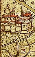
Towns are portrayed at the edges of some maps. They were not directly
relevant to the Dogana and therefore appear as points of orientation at the margins
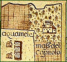
of the maps. Around each urban settlement are small enclosed fields
in which small buildings, crops and trees are shown. These represent
vigne, literally vineyards but in fact used for a wide variety of crops.
Such plots were cultivated by townspeople for subsistence and
trade. This is clearly seen in cadastral documents . The Tavoliere - wide areas of pasture and cornRural land was divided into three main categories:
Most of the land in the Tavoliere was given over exclusively to pasture. The maps show the wide extent of such tracts, portraying shepherds and grazing sheep.
The number of posts varied greatly over time, with frequent changes
in boundaries. These pastoral settlements are scattered within
the grassland areas.
A protected landscape
The manuscript images from this section originate from the documents of the Regia Dogana now kept in the Archivo di Stato Foggia. |
 Looking at the
  Locations were subdivided into 'posts' which were assigned to
individual graziers or groups. A 'post' consisted of the capanne (huts) of the shepherds amid pens fenced by ferule, a type of fennel. The site often had a church and some farm
buildings associated with agricultural production. Under the Dogana regime, there were strict limits to building. The abolition of
the Dogana led to a rapid programme of massaria building in the countryside.
Locations were subdivided into 'posts' which were assigned to
individual graziers or groups. A 'post' consisted of the capanne (huts) of the shepherds amid pens fenced by ferule, a type of fennel. The site often had a church and some farm
buildings associated with agricultural production. Under the Dogana regime, there were strict limits to building. The abolition of
the Dogana led to a rapid programme of massaria building in the countryside.  Some of the maps clearly show arable land, sometimes represented
in brown with a striped texture. The mix of pasture and arable
gave the region its other name of Tavoliere or checkerboard. The amount of cultivated land permitted by the
Dogana varied according to the demands of population pressure, but was
always strictly limited.
Some of the maps clearly show arable land, sometimes represented
in brown with a striped texture. The mix of pasture and arable
gave the region its other name of Tavoliere or checkerboard. The amount of cultivated land permitted by the
Dogana varied according to the demands of population pressure, but was
always strictly limited. 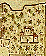
 Patches of enclosed land with buildings and trees represent
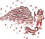
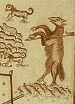 The maps portray the region as seen from the perspective of the
Dogana. Towns and their small fields are marginal. The only activity
shown is grazing and guarding sheep. Marino has analysed the symbolism
of the
The maps portray the region as seen from the perspective of the
Dogana. Towns and their small fields are marginal. The only activity
shown is grazing and guarding sheep. Marino has analysed the symbolism
of the